EXPERIENCE
Transportation | Utility Infrastructure | Rail | Municipal/County CIP | Flood Studies | Education/Facilites
McGray & McGray has more than 20 years of experience surveying for DOT's, RMA's and local roadway bond projects.

Texas Department of Transportation Surveying
Our team has supported TxDOT surveying needs for roadway, highway and bridge projects for more than 20 years across the State. As both a prime contractor and a Texas HUB subconsultant, McGray & McGray has worked on hundreds of projects including: design surveys on US 281 in Blanco County, ROW mapping for 6.4 miles of SH 71 in Travis County and FM 2611 in Brazoria County, and H&V control for aerial mapping on 14 miles of US 290 East. We are TxDOT precertified in 1.9.1, 15.1.1, 15.2.1, 15.2.2, 15.3.1, 15.3.2, 15.3.3, 15.3.4 and 15.3.5.
TRANSPORTATION

CTRMA US 290E Manor Expressway
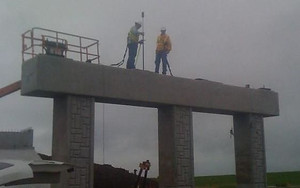
McGray & McGray provided QA/QC surveying services during the construction of the US 290 East Tollway. QA/QC checks throughout the project were regularly performed capturing data on pavement and bridge abutments, bents, and bearing seats, along with other requested checks. Monitoring of MSE walls was performed via shots taken along the top of the wall and photos taken from the base of the wall at specified locations. We also provided surveys of 45 bridge approaches using terrestrial LiDAR scanning.
SH 130 Segments 5 & 6
McGray & McGray provided crews for Quality Assurance surveying services during the construction of Segments 5 and 6 roadway and infrastructure. We provided ROW acquisition surveying services consisting of 16 miles of new toll road from FM 1185 at US 183 to and including the San Marcos River. McGray & McGray analyzed boundaries, prepared GLO permit for bridge crossings over navigable waters, utilized the VRS network, and performed QA/QC. Plats and descriptions for 126 parcels and 56 sheets of ROW map were provided.
UTILITY INFRASTRUCTURE
From water and wastewater transmission to large scale tunnels, McGray & McGray has extensive experience surveying for utility infrastructure.

Downtown Redevelopment Master Plan for Wastewater Tunnel Design
McGray & McGray provided topographic surveys of temporary construction sites, right-of-way survey of 5,000± LF of Riverside Drive and borehole surveys of 25 boreholes on dry land and 20 in Lady Bird Lake. This project also involved determining public and private ownership of Lady Bird Lake (Colorado River) for purposes of creating a subterranean easement (boundary) of the tunnel. QA/QC of the tunnel alignment under Lady Bird Lake during construction was also performed.

City of Austin Downtown Chilled Water System Upgrades
McGray & McGray located below and above ground chilled water appurtenances after installation at various locations in the Downtown District including Green Water Treatment Plant, Third Street, Westin Hotel, and Hotel VanZandt. As-built drawings were also provided.
UT Administration Building Cooling Tower
McGray provided a topographic survey with 1’ contours locating above ground features including buildings, visible utilities, sidewalks, driveways, roadways, fences, signs, valves, meters, curbs, utility poles, and wastewater manhole and storm sewer infrastructure data. This project also involved providing cross sections taken at 50' intervals and locating utilities designated by a SUE subconsultant.
McGray & McGray surveyors have supported local railway and transit projects from initial route and ROW surveys through construction and as-builts.

Plaza Saltillo - Capital Metro Transportation Authority
McGray & McGray provided plats and descriptions of new rail locations, bike trail easements, IH 35 ROW, Brushy Street, and remaining areas of development for rail relocation planning. At the beginning of the project, all easements and encumbrances from IH 35 to Comal Street between 4th and 5th Streets were identified and located, as well as locating geotechnical boreholes and utility test holes along the project route.

Redline and Greenline - Capital Metro Transportation Authority
Our firm provided boundary surveys for eight miles of the CapMetro “Greenline” project and 32-miles of the "Redline" project. These projects had extremely tight deadlines. McGray & McGray staff worked extended hours to complete this project on time. Extensive research was done, not only into the railroad right-of-way but also into each of the 12,000+ adjacent properties along the routes.

Statewide Railroad Survey Support
McGray & McGray provides survey support for a number of railroad companies, including Union Pacific Railroad, BNSF Railway, WATCO Companies, and Hanson Professional Services. Survey needs include facility boundary surveying, railroad right-of-way, topographic surveys, SUE utility designations and construction staking Projects include ongoing work at the Greens Port/Gate 5 site in Houston, Texas, the San Antonio Central Railyard/Port San Antonio, the Hunt Asphalt Plant in Dallas, Texas, the Hebron Railway in Hebron, Texas, and numerous others.
RAIL
MUNICIPAL/COUNTY CIP
As a local Central Texas firm, McGray & McGray supports City and County government and local engineers with surveying for capital improvements.


Select Experience Includes:
City of San Marcos
Hunter Road Water Line
City of Kyle
Elliot Branch Wastewater Interceptor
Bunton Creek Road
City of Pflugerville
Weiss Lane Road Improvements
Pfluger Farm Lane Drainage, Street, and Utility Improvement
Lake Pflugerville Parking Lot Expansion
City of Austin
Shoal Creek-Ridgelea Storm Water Improvements
Holly Street Power Plant Decommissioning
Zilker Metro Park – Barton Creek Trailhead
Forest Ridge Waterline
Gus Garcia Park Improvements
MLK TOD Storm Water Conveyance Improvements
Linger Lane Lift Station Improvements
City of Round Rock
Chisholm Trail Roadway & Drainage Improvements
Travis County
North Central Community Health Center
FM 969 Improvements
Gilleland Creek Trail
Gilbert Road Extension
McGregor Park
Hays County
Nutty Brown Road Drainage
Williamson County
Kensington Place and Windy Park Tributary H&H
Our surveyors have extensive experience with hydrographic and H&H surveys to support flood study projects to FEMA guideleines and specifications.

FEMA Flood Studies
McGray & McGray has supported numerous flood study projects in Texas, performing structure surveys, cross sections, spot elevations and flowlines to FEMA guidelines and specifications in support ofTechnical Support Data Notebook (TSDN). Projects include: Boggy Creek, Shoal Creek, Carson Creek, Bull Creek and West Bull Creek, Cottonmouth Creek, and others.

Waller Creek Tunnel
McGray & McGray performed a topographic survey of Waller Creek watershed, locating visible improvements and utilities, sewer invert elevations and existing easements, and cross-sections of 83 structures with cross-section 100’ upstream per FEMA guidelines. We also performed 3-D laser scanning at Waterloo Park, 6th Street to 2nd Street, and outlet area, borehole locations, property surveys, hydrographic surveys on Lady Bird Lake, utilities and route survey, plats/descriptions of 50 easements, and prepared survey portions of TSDN.
FLOOD STUDIES
EDUCATION / FACILITIES
McGray & McGray provides surveying and scanning for K-12 and higher education facilities from planning through construction.

Austin I.S.D. Schools Projects
Our firm supports the ongoing survey needs for K-12 campuses across the Austin Independent School District. Projects include Akins High School, McCallum High School Capital Improvements, Maplewood Elementary School, Baldwin Elementary, and more. Services include boundary, topographic surveys, SUE utility designations and construction staking.

University of Texas at Austin Projects
McGray & McGray provided project control and boundary surveying services for various projects on the UT Austin campus, including Disch Falk Field, the UT Football Practice field, and the proposed Red River relocation and the UT Austin Basketball Arena site.